Hikes in the Sedona area are primarily what locals call “in and out.” This simply means that hikers will reach the end of their primary trip in and return back to the trailhead on the same route.
These in-and-out hikes are still enjoyable because hikers see things differently on the return trip. Changed lighting, textures and colors and the backsides of formations one does not notice on the trip in. A rich alternative I want to recommend are two excellent loop hikes where hikers experience a constantly changing landscape from start to finish. There are a number in Sedona I have enjoyed.
Two surprised me with incredible variety, awe-inspiring scenery and monolithic rock formations I’ve not seen in iconic Sedona photography.
Courthouse Butte Loop
- Rating: Moderate
- Distance: 4.3 miles
- Elevation change: 334 feet

The first is the Courthouse Butte Loop Trail, accessible from the Bell Rock Trailhead parking lot. A tip before you begin: This is one of the busiest trailheads in the area. Many visitors find this as their first stop before they even drive into the city of Sedona, but don’t be discouraged. Often you can just loop out of the parking area and back in. A drop-in observer leaves after just a few photos.
Like most loop trails, this hike will require navigating via more than just the Courthouse Butte Loop Trail. Right away you will not see the sign for Courthouse Butte loop. From the Bell Rock Trailhead, continue straight on Bell Rock pathway to next intersection. Turn left as others continue towa rd Be l l Rock. You will reach intersection of Bell Rock Pathway, Llama and Courthouse Butte Loop.
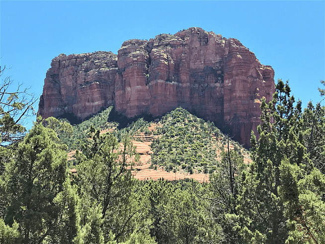
Here take a right on Courthouse Butte Loop trail and head toward the base of the sheer sandstone cliffs ahead. This side is partly shaded early in the day and brilliant red with tan sandstone layers in late afternoon. The trail winds downward into juniper pines and away from the butte above. After a few minutes, you will be surrounded by the butte behind you and a long canyon wall ahead.
Here, you resume eastward toward the back of the butte. As the trail winds to the back of the butte, a surprise awaits: Suddenly into view is a smooth 40- foot-high slickrock knob set apart from the base of the Courthouse foundation.
If you climb around the left edge of the knob, you will have the best panoramic view of the large 5700-foot-tall canyon wall. Here yet another surprise comes into view — twin spires that mark the northeast end of the canyon wall. They are not visible from the road, not even the beginning portion of the trail. I took many photos of the natural Washington monument style towers, unlike any I’ve seen around Sedona. To continue the loop, go back to the base of the knob. There are no signs or cairns [wire cages of rock set up by forest service to mark the trail].
Soon past the right side of the knob you will pick up the path as it heads away from the butte.
The south side is a gentle slope into a creek bed. After you cross over the creek bed, you will connect with the Big Park Loop, now heading back toward the front of Courthouse Butte. The lay of the land changes once again as you rise from the creek bed into an open meadow. Higher now, you see to your left the best view of the Village of Oak Creek.
The trail proceeds to reconnect with Bell Rock pathway but here is where I recommend a new trail that is not yet listed on maps or apps. It’s called the Rector Connector and, instead of going all the way around the front of Bell Rock and along the highway, this is a natural climb between the two signature formations.
Courthouse is steep with cave formations near the top of the 5,412-foot Courthouse summit. You will do some climbing as you approach the narrowest space between the two formations, but enjoy it because you are very near the end. All along are cactus flowers and colorful desert plants at this time of year. You will know as the trail descends and you reconnect with Bell Rock trails and hikers that the trailhead is just ahead. This is the first familiar section you find all day.
One other plus with loop trails: You can proceed clockwise, as I did, or upon a second visit, travel counter-clockwise: Two completely different hikes.
Mescal-Deadman’s Pass Loop
- Rating: Moderate
- Distance: 2.8 miles
- Elevation change: 197 feet
If you want a loop with less parking or tourist crowds, this one fits the bill. I recommend scouting all your hikes ahead of time. You can find specific trail information on a number of online sites. I recommend ones that provide maps and ratings to preview the level of exercise. But keep in mind, as on this hike, 197 feet of elevation change over 2.8 miles is a relatively easy hike. Take Dry Creek Road to the T at Boynton Pass Road and turn right onto Long Canyon Road. On your right there is parking for trails on both sides of the road. Conveniently, Mescal starts just across the road. The first quarter mile is a busy mountain biking trail, so look for the Mescal Connector on your right. This takes you over to the Long Canyon Trailhead with limited parking as well. After just 15 minutes, you are now headed out on Long Canyon Trail toward the wilderness.
Just before you get there you will have limited views of Seven Canyons Golf Course a little below your elevation. Here you take a straight left turn onto Deadman’s Pass Trail and start a steady climb. Atop the natural stair, the trail continues, now left and downhill along the valley with massive red rock walls across the juniper covered floor to your right, the backside of the 5900- foot summit that overlooks Enchantment Resort on the other side. The trail is easy here, mostly downhill, and I spent most of my time looking across the canyon.

At the midpoint, there is a giant amphitheater-size cave way up above the floor, seemingly inaccessible to even the most brave and bold natives who made such natural shelters home more than 900 years ago. On your left Deadman’s Pass Trail connects with Mescal trail. Go left and you will climb again, working your way around the right side of 4,920 foot Mescal Mountain.
This is the steepest part but it comes with great reward. You will find a smooth slick rock sidewalk which navigates you around to the front overlooking Boynton Pass Road. You travel laterally with elevation above and valley below, a great view in every direction.
As you arrive at the next junction, you will see two signs, Mescal Extreme or Mescal Difficult. Let not your heart be troubled. This is a description for mountain bikers who choose the very narrow lower trail or the steeper but wider high trail. They are just feet apart and you can explore either one as you navigate around a canyon cove.
You will be surprised just how easy this part is. Stop to take in the cove. As you leave the cove, you will exit out onto a juniper covered flatland which will return you to the trailhead.
This loop ends so soon you will want to take it again. Go counter-clockwise if you do.
Don Eicher can be reached at 282-7795 ext 126, or email to deicher@larsonnewspapers.com


