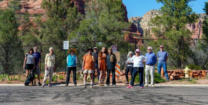
On April 6, two homeowners in the Pinon Woods III subdivision just south of Courthouse Butte in the Village of Oak Creek completed work on a six-foot chainlink fence on a one-foot strip of land that lies between the Coconino National Forest and the end of Pebble Drive, a county road.
Before the fence was put in place, some neighbors assumed that the county road directly touched the forest, in which case nothing would come between the road and a well-worn social trail that runs a quarter mile from the neighborhood to the Big Park Loop trail system on the national forest.
Though the Pebble Drive social trail is not an official Coconino National Forest trail, several residents said they have been using the trail for between 15 and 25 years. Don Kemerling said the trail was there when he and his wife moved to the neighborhood in 1995.
The closest official Forest access points from the location are the Jacks Canyon Trailhead and Bell Rock Vista Trailhead, roughly 2 and 2.5-mile drives from the social trail, respectively.
Cynthia Tierra, who moved to the neighborhood 15 years ago, said she was attracted to the neighborhood in part because she could access the forest on foot using the trail.
“To me [the trail] just symbolizes freedom and the spirit of nature. It’s very, very important to me,” Tierra said. “[The trail] was our nice little secret for many years …. All of my neighbors are upset. All of them. They walk their dogs there. It’s a social thing. This just should never have happened in the way that it did.”
The sting of losing access to the social trail was increased for some residents by the temporary closure of the Bell Rock Vista trailhead — done to limit spread of COVID-19 — two days before the fence went up, making access to the Big Park Loop significantly more difficult.
Some residents question whether the foot-wide boundary gives the owners the right to unilaterally close the forest access there. Three days after the homeowners erected the fence across the social trail, residents created a GoFundMe page to raise $5,000 for legal fees to contest the trail blockage. At press time, 23 donors had contributed a combined $3,075.
Jeff Fox, who lives close to the social trail, thinks the reactions against the fence have been unfair to the homeowners.
“[The homeowners] always owned this piece of land. I don’t know how much land they have before you get on national forest land, but it is their land,” Fox said. “They just allowed neighbors they knew to use it, until the last couple years it hit social media. It’s actually on some apps where it shows it as a trailhead, and that’s what’s really brought the tourists up.”
The Sedona Red Rock News made numerous attempts to contact the homeowners who built the fence for comment, but they did not respond.
The facts regarding the official boundary line at the end of Pebble Drive have not been clear for residents of the neighborhood. The lack of clarity may have been exacerbated by the design of the subdivision and back and forth between the county, Coconino National Forest and the developers during approval in 1995.
The engineers who designed the Pinon Woods III subdivision in 1994 drew the end of Pebble Drive in a flaring bell, or hammer, shape that widens into a 100-foot wide span as it approaches the forest line. The shape of the cul-de-sac might suggest to some observers an intended forest access point.
David Williams, director of Yavapai County development services, pointed out that the shape is consistent with a hammerhead turnaround. A hammerhead turnaround gives long vehicles, like fire engines and delivery trucks, enough space to make a three-point turn using a minimum of surface area.
But the minutes of the January 1995 Yavapai County Board of supervisors meeting, during which the development was discussed, suggest that a forest access point was part of a draft version of the subdivision plan. One of the stipulations the county supervisors gave the developers for final approval in 1995 was “modification of the subdivision plat submittal to eliminate access to the National Forest via Pebble Drive.”
The board’s stipulation continued, “Necessary design modifications are to be … reviewed and approved by Coconino National Forest prior to submittal,” suggesting that the Forest Service at the time did not want an access point at Pebble Drive.
Today, the subdivision plan includes two one-foot by 50-foot projections from the lots on either side of the end of Pebble Drive. The strips of land connect in the middle of Pebble Drive’s terminus, forming a one-foot border of private land — shared equally by the owners on either side — between the national forest and the county road.
The recently built chainlink fence spans the two private properties but was built as a contiguous fence across the line.
Keith Peterson, one of the owners who built the fence — and treasurer for the Pinon Woods III homeowners’ association — applied to Yavapai County for a building permit for a fence on his side of the strip on Feb. 21. Two days later, the lot owner across the street applied for a permit for her side.
By March 28, both of the building permits for the fence were approved by Yavapai County, and construction began a week later.
Jeremy Dye, assistant director of development services for Yavapai county, described the shape of the two lots as “unusual,” but after a review of the permitting records didn’t see anything amiss with the county’s permitting process for the fence.
“Any kind of permit goes through a series of reviews for any jurisdiction that has any kind of regulatory authority … and it’s kind of based on the complexity of the project that’s being done,” Dye said. “In this case here, just the fact that it’s a six-foot chainlink fence, then it really only requires just a few reviews, and so our planner reviewed it, made sure it was within the property line of that property, and then, of course, it did go to flood [control review].”
Tierra said she did not know that a fence was coming until crews from Yavapai Fence in Cottonwood began sinking poles in the ground in early April. Others heard word-of-mouth and social media reports of a fence after a work crew visited the site in February.
“It was just done clandestinely if you ask me. We were not even informed. All of the sudden the posts were going in,” she said.
In the year prior to the building permit applications, the Pinon Woods III HOA’s board of directors did not discuss the fence, according to the HOA’s published meeting minutes.
The HOA’s board did not respond to requests for comment by the NEWS, except with a message apparently intended for someone else: “If you want the HOA to comment on this, write your reply …. Wonder who turned this into the newspaper? J,” the sender wrote in a forward with the request for contact.
Amy Tinderholt, the district ranger for the Coconino National Forest, said that the property owners communicated with USFS staff before construction, but the agency did not coordinate with the owners beyond that.
According to Tinderholt, the Forest Service did not see that there was anything more to do without a legal easement connecting the social trail with the county road.
“Without existing legal access, the Forest Service is not considering adding this trail to our National Forest Trail System at this time, therefore the only action available is to rehab the trail as funding and resources are available. If additional trail access is needed around the Village of Oak Creek, we would [seek comment from] the community to get input on new locations. If this area is identified as a priority, we could look into obtaining an easement at that time,” Tinderholt said.
Several neighbors claimed that the unofficial forest access on Pebble Drive had been advertised online. The only app the NEWS could locate with the Pebble Drive social trail was AllTrails, a trail-finding app with 10 million users, according to the company’s website.
Meaghan Praznik, head of communications and partnerships for Alltrails, said in an email that the company can update trails on the service if they are notified of issues with private property boundaries.
“Unfortunately, even though some trails may be private property, people will hike them and record them as if they are public. We always want to make sure we are showing the most up-to-date trail conditions and availability and regularly work with private landowners/park authorities to make real-time updates on our app,” Praznik wrote. “If there is concern about trespassing on private trails, landowners are more than welcome to contact us and we will mark the trail accordingly.”
Tierra said that she regularly saw cars parked on Pebble Drive near the unofficial access in recent years.
“There were cars parked there quite a lot, yes, and they were a lot of out-of-state license plates. It just became known to the public,” Tierra said.
Other neighbors described the social trail traffic as mild.
In a letter to the NEWS, George and Sybil Larney, 16-year residents of the neighborhood, said hikers accessing the trail had been respectful.
“Neighbors who drive to the trailhead and park their vehicles on the street obey the signs …. Hikers and others accessing the path are well mannered and maintain the quietude of their surroundings,” they wrote.
Tierra said she wishes the neighborhood had received advance notice of the plans and the opportunity to assist the homeowners with problems associated with the social trail.
“I don’t mean to attack the owners of the property, because they have been having problems, too,” Tierra said. “But if they’d talked to their neighbors, we maybe could have helped them somehow. There’s other alternatives.”


