Arizona’s Independent Redistricting Commission is nearing completion of final maps that will shape congressional and legislative districts in the state of Arizona for the next 10 years.
For the last decade, the Verde Valley has been split in Congress.
Camp Verde, Sedona, Oak Creek Canyon, southern Cornville and the Village of Oak Creek are in Congressional District 1, currently represented by U.S. Rep. Tom O’Halleran, a moderate Democrat. This district connects us to Flagstaff, most of the American Indian reservations in the northeast corner of the state, and wraps south along the eastern border of Arizona into the northern suburbs of Tucson.
Cottonwood and northern Cornville are connected in Congressional District 4 with Kingman, Bullhead City and Prescott and the western part of the state down to Yuma, and wrapping north of the Phoenix area to grab Payson, Strawberry and Pine, then south to Florence and San Tan. District 4 is currently represented by U.S. Rep. Paul Gosar, a far-right Republican.
The new draft map would unify most of northeastern Arizona, including Prescott, Flagstaff, the American Indian reservations and the Verde Valley in one congressional district across the northern part of the state.

CD1 is currently a battleground district. O’Halleran, a former Republican in the state legislature who switched parties about a decade ago, has handily won as a Democrat despite a partisan lean of R+6, according to the Cook Partisan Voting Index. The map for the new Congressional District 2 would have a partisan lean of R+15, making such a win for O’Halleran in 2022 far more difficult. It would also be among the largest congressional districts in the country, excluding at-large districts.
Gosar would see his district’s lean drop from R+45 to R+34, but the lines for the new Congressional District 9 would put him in the same district as current U.S. Rep. Debbie Lesko [R-District 8], one of Gosar’s far-right Republican allies. That primary will be brutal.
On the state side, the Verde Valley is currently joined in Legislative District 6 with Flagstaff, the White Mountains, Tusayan, Williams, Payson and Holbrook. LD6 has been represented almost exclusively by Snowflake Republicans, and one from eastern Flagstaff, despite Democrats from Flagstaff, Holbrook and former Jerome Mayor Nikki Check making unsuccessful attempts to unseat them in the general election.
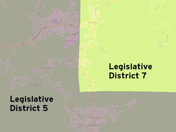
The currently proposed maps do something technically logical but practically stupid: They are fundamentally built on the county lines and thus split the city of Sedona.
The Yavapai County side would be in Legislative District 5 …

… while the Coconino County side could be is Legislative District 7.

This, of course, dilutes our representation in both legislative districts, meaning voter pressure on lawmakers demanding certain action from the Arizona State Legislature would diminish. To convince legislators, we’d have to speak with and convince two different lawmakers to pass the legislation that we want.
On the national level, having Cottonwood and the rest of the Verde Valley split between a Republican and a Democrat isn’t that big a deal because their votes in Congress affect the nation as a whole. As far left and far right as Arizona’s congressional delegation is, our 11 lawmakers have more in common with each other than they do with members of Congress from Vermont, Mississippi, Oregon or Nebraska.
State legislation, however, is far more localized. Uptown should be in the same district as West Sedona, obviously, but also with Cottonwood and Camp Verde, with which we share economic, cultural and familial ties, rather than putting Uptown in the same district as Eager, Florence and Oracle — which is near Tucson.
D5 is roughly contiguous with Yavapai County, adding in a bit of the Black Canyon City area. But the borders of the T-shaped LD7 is a gerrymandered monstrosity — a kitchen sink of whatever didn’t fit in other districts. Splitting a small town like ours is absurd when the commission could make minor adjustments to include the Coconino County side of Sedona and residents of Oak Creek Canyon in LD5, and make some minor shifts to balance out the population representation.
There is still time to add your comments about the new maps, which we will post to our website. Visit Arizona’s Independent Redistricting Commission at irc.az.gov to add your public comments.
Christopher Fox Graham
Managing Editor


