Coconino and Kaibab national forests will temporarily close certain areas to public access beginning Friday and Saturday due to fire danger and for public safety, while all other parts of the national forests outside of the closure areas remain in Stage 2 fire restrictions.
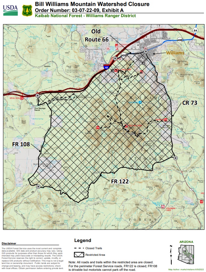
On the Kaibab National Forest, the area of Bill Williams Mountain will be closed beginning Friday, June 17 at 8 a.m. Specifically, public access will be prohibited on all National Forest System lands, roads and trails within the closure area, generally located between County Road (CR) 73, Old Route 66 in the City of Williams, Forest Road 122, FR 108 and I-40. This includes Benham Trail, Bixler Saddle Trail, Bill Williams Mountain Trail, Bill Williams Connector Trail, Buckskinner Trail, City of Williams Link Trail, Devil Dog Loop Trail and Clover Spring Loop Trail. Forest Road 122 will also be closed. FR 108 will remain drivable, however, motorists cannot park off the road.
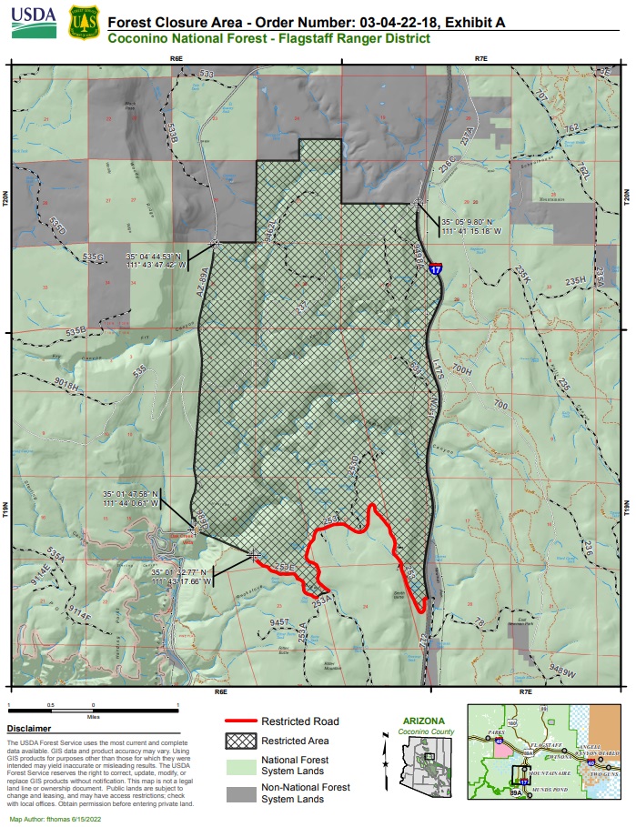
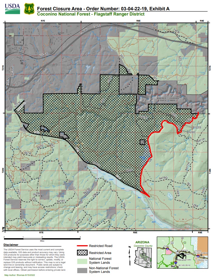
On the Coconino National Forest, the areas of Pumphouse Wash/Kelly Canyon and Fisher Point/Walnut Canyon will be closed beginning Saturday, June 18 at 8 a.m. This includes Pumphouse Wash Dispersed Camping Area, Forest Road (FR) 237 and other roads within the Pumphouse Wash closure area. In the Fisher Point/Walnut Canyon closure area, all forest roads and recreation sites within the area will be closed. This includes Fisher Point, Marshal Lake, portions of the Arizona National Scenic Trail, Canyon Vista Campground, Sandys Canyon Trail No. 137 and more.
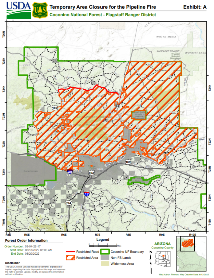
These area closures are in addition to the already-implemented emergency closure of most of the Coconino National Forest north of Interstate 40. For the official Closure Order and a map of this area, please see the official Closure Order.

With regards to both national forests, those with private inholdings will be allowed to access their property via a Forest Service Road but are prohibited from entering the surrounding National Forest lands. Exemptions will be issued for critical activities such as road work and surveys that are vital to continuing restoration operations, time-sensitive utilities and communications site work and emergency response.
Forest managers consider several factors before implementing restrictions or closures, including current fire danger and fire activity, local, regional and national fire preparedness levels, expected weather conditions, availability of firefighting resources and the economic impacts to businesses and communities. All northern Arizona national forests coordinate fire restrictions and forest closures with federal, state, tribal and local partners.
Closures are generally the last resort for land managers, who take many other steps to reduce the potential for human-caused fires and often consider closing only the most critical areas before a full forest closure. As such, additional area closures or even full forest closures could be forthcoming if conditions warrant.
Closures and restrictions will be in effect until hot, dry conditions are no longer forecast to continue and the forests receives enough widespread precipitation to lower fire danger.
For details and maps of these specific closure areas and their boundaries, visit the following pages online:
Coconino National Forest closure area- Fisher Point/Walnut Canyon
Kaibab National Forest closure area- Bill Williams Mountain
Forest Service personnel will make every effort to notify anyone in these areas to vacate before the closure is implemented.
Violating closures and fire restrictions carries a mandatory appearance in federal court, punishable as a Class B misdemeanor with a fine of up to $5,000 for an individual or $10,000 for an organization, or up to six months in prison, or both.
For information on all Arizona state and federal fire restrictions, including an interactive map, visit wildlandfire.az.gov/fire-restrictions. Additional information about the stages of fire restrictions, Forest Orders and general forest conditions can be found at fs.usda.gov/kaibab and fs.usda.gov/coconino.


