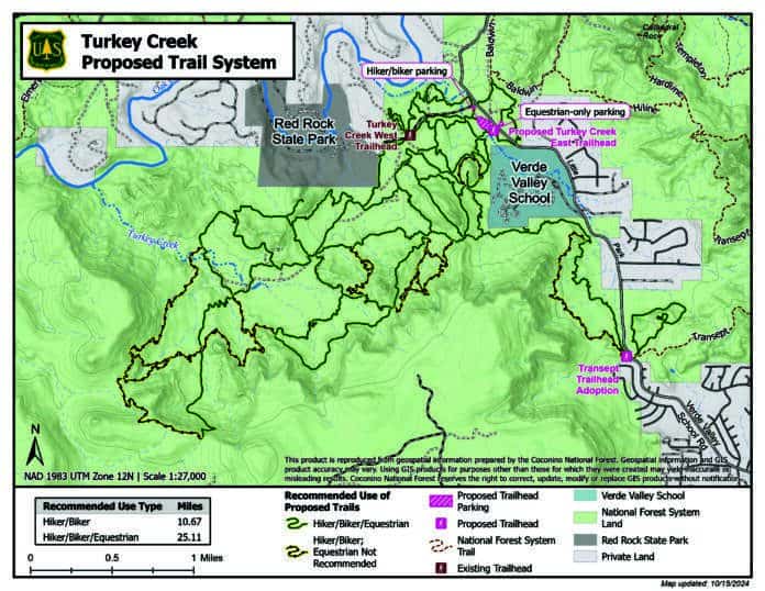
The Red Rock Ranger District has reopened the public comment period for Phase 2 of its proposed Red Rock Trails Access Plan in the Turkey Creek area west of the Village of Oak Creek. The plan proposes constructing 21.2 miles of new trails, recognizing the existence of 10.21 miles of existing trails, rerouting 1.72 miles of trails and destroying 10.57 miles of trails.
The district held a public meeting on Dec. 5 to take comments on the first draft of the proposal, at which numerous residents objected to the elimination of equestrian access in certain areas covered by the plan.
Verde Valley School administration expressed fears about the proximity of hikers to their campus under the original plan.
The Forest Service subsequently dropped the proposal for equestrian closure areas and separated the planned Bell Rock, Cathedral Rock, Doe Mountain and Sedona Red Rock High School-area projects into a separate phase of the project, while redesignating the Turkey Creek proposals as Phase 2. The Phase 1 projects were approved on Aug. 2.
The Bell and Cathedral Rock trail programs will not involve any closures and are expected to be completed by the end of the year. Doe Mountain Trail construction is planed to start in March and will include constructing a loop trail and conducting maintenance on the access trail. Work on the Scheurman Trail Connector that will connect the Upper Red Rock Loop Road to the Scheurman Mountain Trail will begin in the spring, while construction of Cornville’s Oak Creek School bike trail in will commence in the fall of 2025.
The initially-proposed Turkey Creek equestrian closures would have prevented Verde Valley School from taking their students into an area the school has been using as part of its equestrian program since the school’s opening in 1948.
“We were very pleased, and [the Forest Service] came out here three different times and met with us, and walked the property,” VVS Head of School Ben Lee said. “What [the Forest Service is also] proposing to do is to essentially, their word is, ‘obliterate’ all of the social trails that are within 100 yards of our campus. We have two exceptions, which will be our VVS access to those trails, one at the south end of our property, and one on the west side.”
“The school is a large user of this trail system,” District Recreation Officer Phillip Walrod said to the Big Park Regional Coordinating Council, a nongovernmental nonprofit in the Village of Oak Creek. “We worked with the school to make sure that the entrance and exit points out of the school were usable for them, and also ways that we can control public traffic in and out. We didn’t want public traffic to come into the school.”
“We support them fully,” Lee responded when asked if VVS has any additional concerns with the updated USFS plan.
District Ranger Alex Schlueter and Walrod presented the new plans to the BPRCC on Thursday, Oct. 17.
“We’re not currently planning a public meeting for two reasons,” Schlueter said. “We want to be efficient with our resources … We don’t expect a lot of different feedback than we heard from the first round.”
As part of the new plan, Forest Road 216B “is proposed to be closed and restored to a natural setting.”
“The location of the current Turkey Creek East trailhead at the Verde Valley School Road and Turkey Creek Trail Road/FR 216B intersection has during peak times reportedly led to cars overflowing onto the road and blocking traffic,” the scoping letter stated. “Moreover, no trailhead in the Turkey Creek area is large enough to accommodate horse trailers.”
The plan proposes a new trailhead for about 35 vehicles and a separate equestrian-only parking lot that could accommodate five horse trailers, both of which would be located along Verde Valley School Road southeast of the current Turkey Creek East trailhead.
Walrod said that he wants to implement a reservation system requiring riders to call the Forest Service to get a gate code to use the lot.
The Forest Service is also attempting to eliminate natural trails created by users.
“Social trails are unauthorized trails that have been constructed on the landscape,” Schlueter said. “They’re not made with standards as to how much the grade is, how steep it is, where we’re going to have water bars to control runoff, they’re not made what we call sustainably. So we’ve got a major issue out there.”
“There’s a lot of cultural resources out in the Turkey Creek area, some of the user-created went through cultural resource sites,” Walrod said.
The plan can be reviewed at tinyurl.com/RedRockAccessPhaseII and the public comment period will run through Thursday, Nov. 14. Walrod said he was hoping for a decision memo on the plan this winter.
Online public comments on the Red Rock Trails Access Plan Phase 2 can be made at tinyurl.com/RedRockAccessPhaseIIComment, or can be mailed to the Red Rock Ranger District, Attention: Red Rock Trails Enhancement, 8375 SR 179, Sedona, AZ 86351.
Joseph K. G


